UWFPS 2017 daily cold-air pool forecast valid 12/27/2016 0900 MST
Current weather synopsis and nowcast (0-12 h valid 0900 MST 27 December to 2100 MST 27 December):
The cold weather system on Christmas day brought
cold air emplacement and significant fresh snow cover to the
region, setting the stage for a significant cold-air pool episode for
the next several days. Current snow depths range from 7-14" across the
region. Utah lake remains unfrozen but if cold weather continues over
the next week it will likely freeze. The current Great Salt Lake
temperature is just above freezing around 1 C.
Visibility/ceiling: Dense fog in low lying areas, visibility 1/8-1/4 miles, IFR or lower through morning.
Winds: light and variable.
Cloud cover: Partly cloudy outside of foggy areas in low-lying areas.

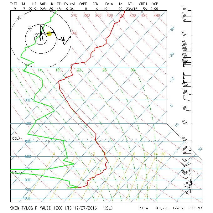
Skew-T with strong temperature inversion 0500 MST 27 Dec
Cold-pool conditions expected next 36 h.
A
strong inversion is noted this morning from the surface to 600 mb. A
weak weather system will graze Utah over the next 24 hr, cooling
temperatures aloft from -4 C to -10 C and weakening the cold-pool but
likely not removing it.
The depth of the polluted layer is expected to be ~200 m in
Cache Valley, and 300-500 m in Utah and Salt Lake Valleys.
Visibility/ceiling:
Dense fog in low lying areas, visibility 1/8-1/4 miles, IFR or lower
through morning. Visibility rising to > 1 mile with ceiling heights
> 2000 m in afternoon
Winds: southwest winds 5-10 mph through noon, reversing to light northwest winds in the afternoon at KSLC
Cloud cover: increasing mid-level clouds associated with weak weather system.
Mid-term forecast (2-4 days):
A short-wave ridge
will traverse northern Utah between Wednesday and Friday. Warm air advection at mountaintop will warm 700 mb temperatures
from -10 C to ~+1 C, resulting in a high-intensity capping temperature
inversion over the Salt Lake Valley from through Friday. Peak cold-air
pool intensity expected on Thursday 29 Dec. The strong capping inversion
height will be descending
during the period. Winds in the boundary-layer will remain light and
variable. Westerly winds ~10-20 kts at 700 mb will likely drive a
channelled jet between 300-700 m AGL into the Salt Lake Valley through
the Jordan Narrows from the South on Friday.
Visibility/ceiling:
Low forecast skill on the fog occurrence and intensity during this
period. stay tuned, as modification of current cold temperatures
important for fog probabilities. Dense fog is possible during morning
hours.
Winds:
light and variable less than 6 kts from surface to 800 mb. 10 kts at
700 mb from west on 13 December increasing to 10-15 kts southwest by 15
December.
Cloud cover: Main concern is dense near surface fog. Large
lake-air temperature differential will increase fog potential near Great
Salt Lake. Deep snow cover will increase change of radiational fog in
all basins.
Long-term forecast (4-7 days):
A
weather system will weaken the cold-air pool late Friday into Saturday.
At this time, mix-out is uncertain. It is possible that the cold-air
pool remains until a front arrives on Sunday 1 January. Fresh snowfall
is likely at this time as well across the region.
Key cold-air pool meteorology definitions:
cold air emplacement
--> Cold-air left behind from a synoptic weather system; significant
cold-air emplacement in the boundary-layer will lead to a more intense
cold-air pool
when warming aloft commences.
warm air advection at mountaintop
--> A key driver of cold-air pool intensity. Very warm temperatures
at 700 mb relative to surface temperatures result in a more intense
capping
inversion.
lake-air temperature differential
--> When the lake surface is warmer than the overlying air (most
typical scenario), the lake surface acts as a moisture and heat source,
increasing
chances for dense fog formation.