Friday, January 18, 2019 noon.
Weather Synopsis:
Persistent cold-air pool forecast valid Friday 01/18/2019 12:00 noon MST
This will be updated every other day unless during major PCAPS (will be updated daily).
Summary: A major storm system brought heavy rain and snow to Utah is winding down on Friday. Weak high pressure will result in brief cloud-topped cold-air pool/inversion through the weekend, with only minor impacts to Valley air quality. A major snowstorm is looking more likely for Monday. This could set the stage for a large high pressure system over the Western US with snow on the ground in northern Utah Valleys, potentially leading to a major persistent cold-air pool episode beginning around Saturday 26 January if current model forecasts hold. Stay tuned.
Saturday 20 January:
Mostly cloudy with sprinkles or flurries possible in the morning. Weak cold-air pool in place in the cloud-topped inversion. PM2.5 concentrations between 5-10 micrograms/m3.
Mostly cloudy with sprinkles or flurries possible in the morning. Weak cold-air pool in place in the cloud-topped inversion. PM2.5 concentrations between 5-10 micrograms/m3.
High 42 F Low 33 F
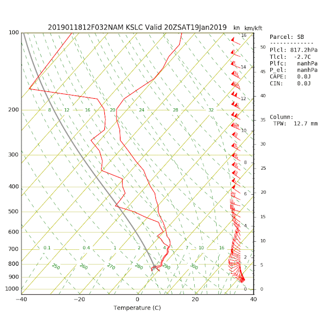
NAM model sounding showing the deep cloudy inversion layer between the surface and mountaintop (700 mb):
Sunday 21 January:
Partly cloudy. Weak cold-air pool in place.
PM2.5 concentrations between 8-14 micrograms/m3.
Partly cloudy. Weak cold-air pool in place.
PM2.5 concentrations between 8-14 micrograms/m3.
High 45 F Low 33 F
Monday 22 January:
Cloudy, 70% chance of snow. Significant accumulations possible.
High 35 F Low 21 F.
Mostly cloudy, cold.
High 30 F Low Saturday night 24 F.
Wednesday 24 January:
Mostly cloudy chance of light snow.
High 37 F Low Sunday night 25 F.
Mostly cloudy chance of light snow.
High 38 F Low Monday night 24 F.

No comments:
Post a Comment