UWFPS 2017 daily cold-air pool
forecast valid Sunday 01/29/2017 8:00 MST (8:00 am local time)
Summary: The most significant cold-air pool episode of the 2016-2017 winter is underway. Pollution
concentrations will increase daily through Thursday. Mix-out time is uncertain as the system next Friday-Saturday may be too weak to remove Valley inversions.
Current
weather synopsis and short-term forecast for Sunday 29 January:
The temperature inversion continued
to lower and strengthen Saturday night (for the second night in a row), and this trend is expected to continue
into Monday.
 |
| 1200 UTC 29 January KSLC ounding. Note the strengthening and descending temperature inversion compared to past days. |
Fortuitously for aircraft operations, the cold-air pool has started out without much dense fog. As of 8 am, mostly clear conditions with visibilities around 5 miles in haze were observed in the Salt Lake and Utah Valleys. Localized dense fog was being reported in the Cache Valley.
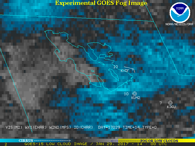 |
| Satellite fog product at 8 am. Note the lack of yellow colors (fog) over all areas. |
Given that boundary-layer moisture is only modestly increasing due to minimal snow melt and cold temperatures, persistence forecast will be used at this time. However, an expansion of low clouds and fog is probable over the next day or so.
Visibility/ceiling/clouds: Mostly sunny 10 am- 5 pm all areas, with the possible exception of Cache. Cold with highs in the 20s, lows in the 5-10 F range. 30% chance of low clouds/stratus development in the Salt Lake and Utah Valley and 50% chance of fog in the Cache Valley after 6 pm. Ceilings most likely to remain above 2500 ft AGL with visibility in the 3-5 mile range in Salt Lake Valley. Ceilings less than 500 feet and visibility less than 1/2 mile possible in Cache.
Visibility/ceiling/clouds: Mostly sunny 10 am- 5 pm all areas, with the possible exception of Cache. Cold with highs in the 20s, lows in the 5-10 F range. 30% chance of low clouds/stratus development in the Salt Lake and Utah Valley and 50% chance of fog in the Cache Valley after 6 pm. Ceilings most likely to remain above 2500 ft AGL with visibility in the 3-5 mile range in Salt Lake Valley. Ceilings less than 500 feet and visibility less than 1/2 mile possible in Cache.
Winds: light and variable.
Monday
30 January:
The
cold-air pool will continue to strengthen Monday, and pollution levels should
continue ramping up each day through Thursday with the combination of a
descending strong, low-level capping inversion and increased emission rates
during the work week. Partly cloudy skies expected with morning fog burning off by 10 am in Cache Valley. Cold, highs in the 20s, lows in the
5-10 F range.
Visibility/ceiling/clouds: Mostly sunny 10 am- 5 pm all areas. 30% chance of low clouds/stratus development in the Salt Lake and Utah Valley and 50% chance of fog in the Cache Valley before 9 am and after 6 pm. Ceilings expected to remain above 2500 ft AGL with
visibility in the 3-5 mile range in Salt Lake Valley. Ceilings less than
500 feet and visibility less than 1/2 mile possible in Cache.Winds: light and variable.
Tuesday- Thursday 31 January - 2
February:
The cold-air pool will continue with pollution levels
continuing to climb.
If a stratus deck forms during this period, then pollution levels will not climb as fast as if conditions are less cloudy. Mid- and high-level clouds will also impact the cold-air pool during this time, resulting in less cooling at night, and a decreased chance of dense surface fog. Winds will also begin to increase and be channelled into the Salt Lake Valley from the south through the Jordan Narrows gap Wednesday into Thursday as the storm system approaches California, potentially resulting in impressive gradients in pollution between the Utah Valley and southern Salt Lake Valley where mixing of clean air will potentially reduce pollutants and the northern Salt Lake Valley and Great Salt Lake where pollution will have accumulated for several days as nocturnal drainage winds take pollutants out over the Lake. The top of the inversion will lower to ~600 m above ground level, with most pollution below 400 m AGL in the Salt Lake and Utah Valleys. These southerly winds are expected to start eroding the top of the cold-air pool on Thursday, making for a shallower polluted layer that could be harder to sample with the aircraft.
If a stratus deck forms during this period, then pollution levels will not climb as fast as if conditions are less cloudy. Mid- and high-level clouds will also impact the cold-air pool during this time, resulting in less cooling at night, and a decreased chance of dense surface fog. Winds will also begin to increase and be channelled into the Salt Lake Valley from the south through the Jordan Narrows gap Wednesday into Thursday as the storm system approaches California, potentially resulting in impressive gradients in pollution between the Utah Valley and southern Salt Lake Valley where mixing of clean air will potentially reduce pollutants and the northern Salt Lake Valley and Great Salt Lake where pollution will have accumulated for several days as nocturnal drainage winds take pollutants out over the Lake. The top of the inversion will lower to ~600 m above ground level, with most pollution below 400 m AGL in the Salt Lake and Utah Valleys. These southerly winds are expected to start eroding the top of the cold-air pool on Thursday, making for a shallower polluted layer that could be harder to sample with the aircraft.
Visibility/ceiling/clouds: 30% chance of stratus and fog. Ceilings less than 1000
feet and visibility less than 1/2 mile possible if low clouds and fog occur.
Partly cloudy. Cold, highs in the
20s, lows in the 5-10 F range.
Winds:
light and variable within cold-air pool near surface. Elevated 5-15 knot southerly flows between 200 and 800 m above ground level in the Utah and Salt Lake Valley.
Friday 3 February – Sunday 5
February:
Complex potential decay period of the cold-air
pool. Details are uncertain at this time as models do not agree yet on either the strength of the remaining temperature inversion or if the storm system will be cold enough to easily scour out pollution from the low elevations of the Great Salt Lake or Cache Valley. Stay tuned as we get closer and model skill improves.
No comments:
Post a Comment