Key
summary: Moderate cold-air pool episode in Salt Lake and Utah Valleys (strong in Cache Valley) has begun. At this time it appears the episode will continue until sometime Wednesday night or early Thursday morning January 18-19th. This episode will potentially be followed by several
major rain/snow storms through Monday January 23rd.
While drier air is expected to reduce low clouds starting Monday, fog will be a major
concern for aircraft operations Monday-Wednesday. Short-term now casting will be critical for flight planning decisions.
Current weather synopsis and nowcast
(0-12 h valid 1830 MST 14 January 2017 to 0700 MST 14 January).
PM2.5 Pollution levels have increased to 15-28 micrograms/m3 this evening in the Salt Lake Valley at UDAQ and University of Utah, and other monitors:
 |
| University of Utah Real-time air quality interface. Courtesy of Alex Jacques. |
A stratus deck located at mid-elevation mountain slopes about 1,600 feet above the Great Salt Lake Basin expanded over northern Utah today:
MODIS satellite imagery over northern Utah late morning 1/14/2017. Lake surfaces are shown in dark blue. Light blue represents snow cover while white represents stratus clouds.
Beneath the cloud deck, cooler temperatures aided by cool Great Salt Lake surface temperatures resulted in an inversion Saturday evening.
 |
| 5 PM Saturday 14 January 2017 KSLC Rawinsonde. Note the temperature inversion associated with the stratus cloud layer. |
This cloud deck has reduced visibility to 5-9 miles with ceiling heights around 1600 feet above ground level. Models continue this stratus deck through most of the day Sunday. Therefore, similar conditions (stratus deck with ceilings ~1500 feet) as observed Saturday are likely Sunday late morning/ early afternoon for the flight arrival. Patchy dense surface fog is also possible in the Cache Valley Saturday night into Sunday morning.
Sunday night, drier northwest flow will likely erode these clouds. The concern, thereafter, is the formation of dense surface fog in low-lying areas during nocturnal cooling of the moist boundary-layer each night during Monday-Wednesday period. It is also possible that another period of elevated stratus re-forms Tuesday.
Visibility/ceiling/clouds: Stratus deck located between 1000 and 2000 ft above ground level expected overnight into Sunday. Visibility < 5 miles at times.
Winds: light and variable.
Short-term forecast (12-36 h
forecast Sunday 15 January):
cold-air pool conditions expected to continue as a ridge of high pressure builds over the region.
Morning fog possible favoring Cache
Valley. Otherwise, overcast with a stratus cloud layer with highs near 30 F in Salt Lake and Utah Valley and 22 F in
Cache Valley.
Visibility/ceiling/clouds: Stratus deck located between 1000 and 2000 ft above ground level
expected to continue through the afternoon Sunday. Visibility < 5 miles at times.
Winds: light and variable.
Mid-term forecast (Monday-Wednesday 16-18
January):
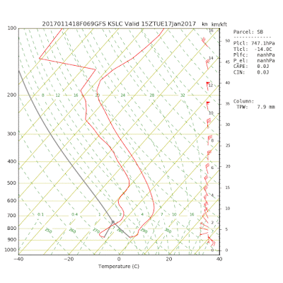
Moderate cold-air pool conditions, peaking on Tuesday into Wednesday. Recent
model runs have strengthened the Sunday-Wednesday cold-air pool episode
somewhat. A ridge of high pressure will be
building over Utah starting on Sunday. Warm air advection during
at mountaintop will warm 700 mb temperatures from -5.0 C on Sunday to around 0
C on Monday and +2 C on Tuesday. This will resulting in a moderate-intensity
capping temperature inversion or cold-air pool over the Salt Lake Valley
beginning Saturday night and continuing through Tuesday or Wednesday. A stronger cold-air
pool is likely in the Cache Valley where snow cover remains on the ground and
surface temperatures will run 10 F colder than in the Salt Lake Valley.
Visibility/ceiling/clouds: Low clouds and fog possible (most widespread in the
morning) below 775 hPa level. Please stay tuned to rapid changes in fog forecast, as fog occurrence is very difficult to forecast and highly variable in space and time within Utah basins!
Winds: generally light and variable.
 |
| GFS Model forecast 0800 MST Tuesday January 17th. |
 |
| Utah Division of Air Quality forecast as of 14 Jan 8 am. |
Long-term forecast (Thur-Sun Jan
19-22):
A
significant and prolonged series of storms (with no inversion or cold-air pool conditions) is expected beginning Thursday 19th January. At this time significant rainfall followed by significant snowfall is forecast. Models also hint at colder air approaching from the west toward the 22nd January. Stay tuned.

No comments:
Post a Comment