Key
summary: Moderate cold-air pool episode in Salt Lake and Utah Valleys is underway (strong in Cache Valley). At this time it appears the episode will continue until
early Thursday morning January 19th, followed by several storms through Monday January 23rd.
Low clouds appear locked into Utah basins. Persistence forecast used at this time next 24-48 hr.
Current weather synopsis and short-term forecast (12-36 h
forecast from Monday am 16 January-Tuesday am 17th January):
Cold-air pool conditions expected to continue as a ridge of high pressure builds over the region.
Cold-air pool conditions expected to continue as a ridge of high pressure builds over the region.
Visibility/ceiling/clouds:
Persistent stratus deck remains in the Great Salt Lake basin. Visibility around 7 miles in the Salt Lake and Utah Valleys. Stratus deck has lifted significantly to 2300 ft above ground level in Salt Lake Valley and has also thickened enough to result in light snow flurries. Persistence is best forecast for the rest of day. There is a 30% chance that the clouds break up this afternoon. Low clouds expected to burn off this morning in the Cache Valley after very cold temperatures (0 F) and fog (visibility 0.75 miles).
Winds: light and variable.
PM2.5 Pollution levels have remained steady in the 20 micrograms/m3 overnight in the Salt Lake Valley Much higher PM2.5 continues in Cache Valley (over 45 micrograms/m3).
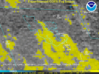
Pesky low clouds continue across the Salt Lake Basin (yellow color in the image below):
A temperature inversion remains in place across the region, as seen by the 5 am Jan 16th Salt Lake Airport sounding.
Visibility has been steady around 5-7 miles all night with ceiling heights now ~2300 feet AGL at the Salt Lake International Airport.
There is a chance that the low clouds break up Monday afternoon, as all numerical weather models forecast low cloud break-up on Monday afternoon. However, persistence is generally the best forecast, so the most likely scenario is the low clouds continue.
Mid-term forecast (Tue-Thur 17-19
January):
Moderate cold-air pool conditions continue until end of episode on Thursday. A axis of ridge of high pressure will be centered over Utah on Tuesday. Warm air advection during
at mountaintop will warm 700 mb temperatures from -5.0 C on on Monday morning to around 0 C by Tuesday evening.
If the stratus deck remains in place, pollution levels will level off in the 30 micrograms/m3 range in Salt Lake Valley Mon-Wed. If the inversion is able to tighten in depth, pollution levels will rise. Cache Valley pollution levels will continue to rise daily through Wednesday.
A stronger cold-air
pool is in place in the Cache Valley (where snow cover remains on the ground) and
surface temperatures will run 10 F colder than in the Salt Lake Valley.
Visibility/ceiling/clouds: 60% chance of low clouds below 775 hPa level with ceiling heights >1,000 feet and visibility > 4 miles. Fog possible with <1/2 mile visibility in Cache Valley and any areas that the low clouds dissipate in Monday afternoon.
Winds: generally light and variable on Tuesday. Southerly
winds increasing with a channeled jet located between 300-1000 m AGL in
Salt Lake and Utah Valley ahead of storm system on Wednesday and Thursday morning.
Long-term forecast (Fri-Mon Jan 20-23):
A
significant and prolonged series of storms (with no inversion or
cold-air pool conditions) is expected beginning Thursday afternoon 19th January.
At this time precipitation is
forecast. Models also hint at colder air approaching from the west
toward the 22nd January, which could set the stage for a stronger inversion in the Salt Lake Valley with snow on the ground the last week January or early February. Stay tuned.
|


No comments:
Post a Comment