UWFPS 2017 daily cold-air pool
forecast valid Thursday 01/26/2017 10:30 MST (10:30 am local time)
Summary:
A strong cold-air pool
will set in during the afternoon Friday and continue through early next week,
with pollution build-up likely starting with the Friday evening commute. Periods of dense fog and areas of stratus are possible
during this episode, particularly in the Cache Valley and near the Great Salt Lake and will have to
be carefully monitored for flight operations.
Current
weather synopsis and short-term forecast for Thursday 26 January:
A final weak weather system is crossing Utah Thursday morning. As of 10 am, web cameras and surface observations indicated that visibility was improving from north to south.
For "non-inversion" flight operations this afternoon and evening:
Visibility/ceiling/clouds: Minimum visibility 3-4 miles in scattered snow flurries, otherwise > 6 miles. Ceilings between 3000-4000 feet in snow flurries, otherwise > 4000 feet. There is a slight chance (10%) of dense fog formation after sunset.
Friday 27 January:
Partly cloudy. Cold, highs in the 20s, lows in the 5-10 F range. 20% of dense fog at Salt Lake Airport and Logan Airport in the morning, 30% chance of stratus cloud deck, favoring Great Salt Lake and Cache Valleys.
Visibility/ceiling/clouds: 30% chance low stratus deck or dense fog, with ceilings less than 1000 feet and visibility less than 1/2 mile possible. If this does not materialize, no visibility issues expected.
Winds: northerly, 5-10 knots.
Saturday 28 January:
Cold-air pool conditions with moderate to strong temperature inversion. Cold, highs in the
20s, lows in the 5-10 F range. 20% of dense fog at Salt Lake Airport and
Logan Airport in the morning, 40% chance of stratus cloud deck, favoring Great Salt Lake and Cache Valleys.
Visibility/ceiling/clouds: 30% chance low stratus deck or dense fog, with ceilings less than 1000 feet and visibility less than 1/2 mile possible. If this does not materialize, no visibility issues expected.
Winds: light and variable.
Sunday 29 January - Tuesday 31 January:
Cold-air pool conditions with moderate to strong temperature inversion through at least Monday, likely continuing on past that. Pollutant concentrations likely increasing
each day in all urban Utah Valleys. Unknown variables are 1) how much
nighttime cooling occurs (clear or cloudy), 2) the amount and persistence
of low clouds and fog, 3) how much mid-level clouds and weakening of the inversion aloft occurs toward Monday and Tuesday; these variables will impact the strength of the inversion during this time. Stay tuned.
Wednesday 1 February - Friday 3 February:
Forecast
models do not agree at this time on the evolution of the cold-air pool
after Tuesday, with some calling for a mix-out mid-week and others
continuing the cold-air pool until the end of next week. The European model (ECMWF) ensemble keeps cold-air pool conditions until Friday, 3 February or Saturday, 4 February (see plot below):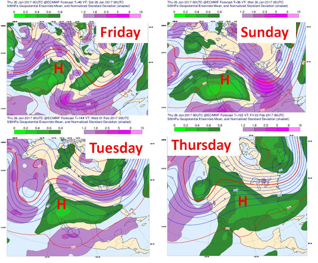 |
| 500 hPa forecast showing inversion conditions through next Thursday. 2 February. |
No comments:
Post a Comment